

Salt Lake Human Induced Regeneration.
Native Vegetation Asset Account.
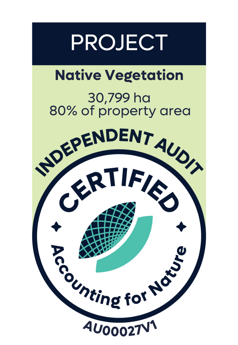
Environmental Account: AU00027
Account Holder: GreenCollar
Environmental Asset: Native Vegetation
Asset Account ID: AU00027V1
Registration Date: 9 December 2021
Certification date: 23 December 2025
Certification pathway: Independent Audit (limited assurance)
Purpose: To assess and track native vegetation condition over time as a key indicator of ecosystem health and land management outcomes.
Current land use: Grazing and carbon sequestration
Area: 30,779 ha (80% of property area)
Scale: Project
Method: AfN-METHOD-NV-03
Asset Account snapshot.

Asset summary.

Asset statement.
-
9 December 2021 - Registration Date
-
23 December 2025 - Certification Date
Significant outcomes.
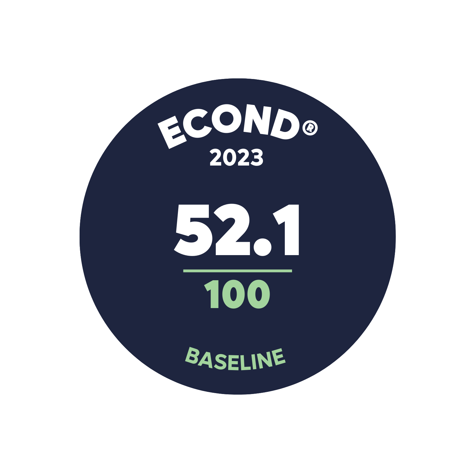
The 2023 Econd® score for Native Vegetation is estimated to be 52.1. The Econd® scores for each assessment unit were approximately equal, with Gibber Transition Shrublands (AU5) scoring the highest at 52.6 and North-west Floodplain Woodlands (AU3) scoring the lowest at 48.6. The overall condition is consistent with expectations based on the land use history within the project area.
For all Assessment Units, site context and non-native cover were the highest scoring indicators, reflecting the intactness of the native vegetation asset in the area on and surrounding Salt Lake. Across the assessment units, indicators related to trees (ie Tree Basal Area, Large Trees, Tree Richness and recruitment of canopy species) were consistently among the lowest scoring indicators. Low scores for these indicators (particularly tree basal area and large trees) are expected within regenerating systems.
While recruitment of canopy species is low, there is evidence of recruitment of shrubs species (239 individual plants <1m tall, across 37 of the 48 surveyed plots).
Shrub basal area scores substantially higher than tree basal area in all assessment units. Seven plots across the account are being penalised for having more than 200% of the benchmark score for basal area of shrubs, with four of these being in Assessment unit 4, which has the lowest shrub basal area condition score.
The observed trend of higher shrub basal area and shrub recruitment and lower tree basal area and recruitment of canopy species is expected to be due to the natural succession of vegetation in a regenerating system. Native shrub species (such as Eremophila sturtii, Senna artemisioides and Dodonaea viscosa) are expected to initially colonise the area before senescing and allowing larger longer-lived species to colonise such as Casuarina species, Eucalyptus species and larger Acacia species. Progress of these indicators will be a focus of ongoing monitoring.
Limitations & disclosures.
Scope
This is a project scale (80% of the property) assessment based on a targeted assessment of native vegetation condition within the environmental accounting area. As such, condition estimates are expected to be representative of the native vegetation within the project area only and not the entire property.
Stratification
Vegetation Classes were delineated directly from the mapping product. After survey work was completed, the mapping of vegetation class 57 (AU1) was determined to likely be inaccurate, so it was merged with vegetation class 103 (AU5) as it was determined to be the best match based on the observed vegetation.
Reference Benchmarks
Reference Benchmarks have been taken at the level of Vegetation Class, and not the finer scale Plant Community Type (PCT). This has been done for two reasons: i) Basal Area benchmarks are not available at the PCT scale; and ii) within the Mulga Lands published PCT benchmarks for Species Richness and Large Tree counts are derived from the combination of Vegetation Class and IBRA bioregion, resulting in no difference between using the published benchmarks at the PCT or Vegetation Class scale. GreenCollar will continue to monitor the published PCT benchmarks for updates, and if finer scale benchmarks become available, they will be adopted in future reporting periods for this account.
Data Collection
Site context was defined using the best available spatial mapping of native vegetation extent for NSW developed under the State Vegetation Type Map program (version1.2 - 5m Raster). The authors are not aware of any other currently available products that are more contemporary and ‘fit for purpose’. During the next reporting period, an assessment will be done to determine if any new datasets have become available which can be used to determine site context for that reporting period.
Last update: 22 December 2025


Environmental Account.
Learn more about the Environmental Account.